The topic of this month's
Accretionary Wedge is "
Geological Heroes".
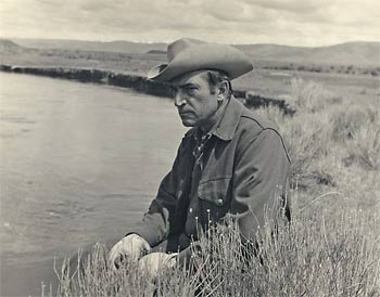
The hero I picked was the hydrologist/gemorphologist Luna Leopold. In the 1950s and 1960s Leopold, along with
Reds Wolman,
Arthur Stahler, and others, he helped to change geomorphology from descriptive and qualitative to a quantitative, process based science. In particular, Leopold focused on rivers, studying not only how their forms were linked to various watershed attributes [landcover, climate, etc] but how rivers respond to perturbations to these attributes. For example, how does a river's shape, width, and depth react to an increase in discharge? In
the classic text of fluvial geomorphology,
Fluvial processes in geomorphology, Leopold [with coauthors Reds Wolman and John Miller] wrote about comparing river meanders of different rivers
The presence of the large meanders, however, poses several problems. First, how and when were such meanders initiated? Second, why do the appear to be unusually large? Third, how are they maintained as the stream corses the bedrock? Was the meander form inherited from an earlier time when the river flowed at a higher level, perhaps on a dispositional or erosional surface no longer evident in the present topography? Or do the large meanders suggest that at one time much larger volumes of water were carried by the Susquehanna? If so, did these larger rivers provide greater energy with which to mold the larger bend in bedrock? [Leopold et al. 1964]

Leopold had a long and varied career, with almost 200 publications. These range the spectrum from remote field work on the Colorado River in the Grand Canyon, to flume work in the laboratory. He was at times the chief hydrologist of the USGS, chair of the geology department at University of California-Berkley, and president of the Geological Society of America.
Leopold, the son of pioneering ecologist Aldo Leopold, was involved with important studies on the environmental impact of human development. A study of the possible impacts of a jetport to be built in the Everglades helped to stop it from being built.
Like his father, he as spoke about our interaction with the environment and our ethical obligations to it.
Speaking of the Persians who dominated Asia Minor in the 5th century B.C., Herodotus said, “They never defile a river with the secretions of their bodies, nor even wash their hands in one; nor will they allow others to do so, as they have a great reverence for rivers.” It is the last phrase that deserves our attention. The river is like an organism; it is internally self-adjusting. It is also resilient and can absorb changes imposed upon it, but not without limit. The limit beyond which a river cannot adjust is well illustrated by some of the effects of our national program of channelization, in which we have already dredged, straightened, channelled, revetted, trained, and “improved” more than 16,500 miles of river channels in the United States, quite apart from the thousands of reservoirs already built.....
Man’s engineering capabilities are nearly limitless. Our economic views are too insensitive to be the only criteria for judging the health of the river organism. What is needed is a gentler basis for perceiving the effects of our engineering capabilities. This more humble view of our relation to the hydrologic system requires a modicum of reverence for rivers. [Leopold 1977]
Most of his publications can be downloaded from the Virtual Luna Leopold Project
Sources:Leopold, L., Wolman, G., Miller, J. 1964.
Fluvial processes in geomorphology. W.H. Freeman and Company, San Fransisco.
Leopold, L. 1973, River Channel Change with Time: An Example. Geological Society of America Bulletin. 84:1845-1860.
Leopold, L. 1977. A Reverence for Rivers. Geology. 5:429-430.